back to FS2000 main page
back to FS98 main page
Some navigation dedicated sites

Hundreds major-airports and approach sheets at one Swedish site.

Lot's of USA navigational data

All about ALLNAV: My missing navaids scenery, giving you all navaids of the world in one file.

Collection with many Hawaii (985Kb) approach sheets and Caribbean (1,5Mb) approach sheets in *.jpg format.

An Austrian site with lot of official Austrian navigational information. VFR and IFR!

USA VFR charts online!
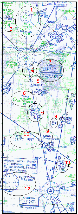
Please, don't forget to vote today: Vote for my Site on the
Avsim Top 100!


Sample chart

Below you will find a part of the Jeppesen European low altitude chart (5-6). It shows a area north of Paris between Lille and Chatillon. In this lesson I will show you some basic information that can be found on these charts. To make it clear where it's all about I added some circles and red numbers. The numbers are referring to the left part of this page, which shows the meaning of the symbols. Just check it out and take the time for it. If you don't like to do it online, just save this page and it's image and do it off-line.

If you have a printer (and better a color printer) print this page and start flightsimulator. You can get a little experience after reading the complete text next to the image below:

Place yourself in slew mode (press Y)at Cambrai VOR (N50:13:42 E003:09:06) and put 112.6 frequency at NAV1. Check the distance (should be zero or near to zero).

Now put 117.6 (Chatillon VOR at the bottom of the image) and try to figure out the heading to this beacon at your instruments.


SMALL PART OF JEPPESEN LOW ALTITUDE CHART (SAMPLE)
1. Lille (Lesquin)has a VOR only (more simple circle) ID LEQ with freq. 109.6. A ILS glideslope is indicated including a NDB (the small green circle) with ID LL and freq.332. Airport altitude=157ft
2. Lens Benifontaine (alt. 187) is only indicated by the small green airport sign. The name is written in small font which indicates that the airport is not included in the airway manual.
.
3. Cambrai VOR includes DME. You can see it at the second circle in the bigger VOR indicator and also at the small 'D' in the text box preceding the frequency (112.6) and ID (CMB). The DME makes it possible to check the distance to the beacon at the planes instruments.
4. The blue line beneith the VOR indicator starting with 169 is a airway (directing Chatillon VOR).If you would be positioned excactly at CMB VOR you need (to fly) radial 169 to reach Chatillon.
5. VERMA is a reporting point but as it is indicated as a open triangle it is only a on-request reporting point.Distance between CMB and VERMA is 14 NM.
6. Peronne-St.Quentin is written in large font, so it's approach sheet will be included in the manual.
7. Above the airway centerline you will find the total distance between two navaids (68 within the six-sided box). 28 is the distance between two intersections/reporting points. Within the centerline you will see the Airway designator (name) B3. Below the centerline altitude restrictions: FL60 = Minimum enroute altitude, 3200T=minimum obstruction clearance altitude, and 2200a= route minimum of-route altitude.
8. The large 2 and smaller 7 indicates the main off route altitude in the chart grid in hundreds of feet.
9. TALUN is a intersection and reporting point (filled triangle). In this example it is only a reporting point for airway G40. For airway B3 this is a on-request reporting point.
10. The arrow gives you the possibility to check your position with MTD (Montdidier) VOR, frequency 113.65 when passing TALUN.
11. R9 is a one-way airway
12. Boursonne (BSN, 112.5) is VOR only again. Compare it to Chatillon, which is VOR/DME


CLICK HERE TO VISIT THE WORLD'S TOP 1000 LIST!