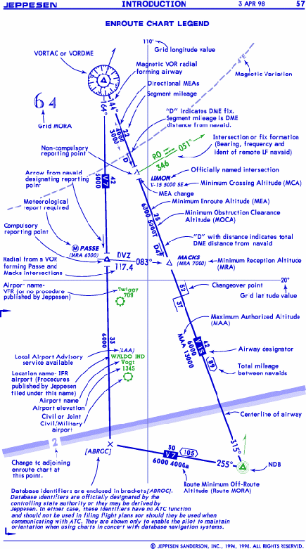
AIRWAY AND ROUTES CENTER LINES
Airway /Route
Diversionary Route, Weekend Route (Europe)
LF Airway
Overlying High Altitude Airway/Route
Oceanic Transition Route
RNAV Airway/Route
FIXES
Compulsory Reporting Point
Non-Compulsory Reporting Point
Low Altitude Compulsory Reporting Point
Low Altitude Non-Compulsory Reporting Point.
Mileage Break/Turning Point
Meteorological report required (unless instructed otherwise), giving air temperature, wind, icing, turbulence, clouds and other significant weather. Report to controlling ground station, or station indicated.

Holding pattern. DME figures, when provided, give the DME distance of the fix as the first figure followed by the outbound limit as the second figure.
Length of holding pattern in minutes when other than standard.

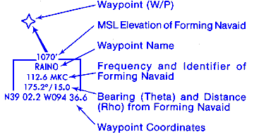
NavData identifier [in square brackets] is included when the fix or mileage break is unnamed, or named with other than a five character name and no country assigned identifier. Its use is to assist the pilot with an on board NavData database to associate database information with chart information. The fix officially named "115°W" is carried in the database as "11YEU" (included after October 14, 1994.) NavData identifiers are Jeppesen derived only, and should not be used for ATC flight plan filing or used in ATC communications.

Fix name with Minimum Crossing Altitude (MCA) showing airway, altitude, and direction, and Minimum Reception Altitude (MRA).
Official fix name (with country assigned identifier in parentheses). Several countries throughout the world assign identifiers for use in flight plans.
LF bearings forming a fix are to the navaid.
VHF radials forming a fix are from the navaid.
VHF frequency and identifier included when off chart or remoted.
LF frequency, identifier and Morse Code included when off chart or remoted.
Arrow along airway points from the navaid designating the reporting point. Other published radials may be used if they are greater than 30 degrees from the airway being used and are not beyond the COP.
Fix formed by 55 DME from MAZ navaid.
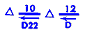
"D" indicates DME fix and distance from the station that provides the DME mileage.
Airway and route designators. Negative (white letters in blue) designators are used for distinction.
A-Amber. Some countries use the phonetic alphabet in lieu of "colored" designations, as Alpha in lieu of Amber, Golf in lieu of Green, etc.
ADR-Advisory Route,
AR-Atlantic Route, Canada Alpha Route
ATS-Designated route without published identifier
AWY-Airway
BR-Bahama Route, Canada Bravo Route
B-Blue, Bravo
Direct Route,
D-(suffix) Advisory service only
DOM-Domestic Route. Use by foreign operators requires special authorization.
F-(suffix) Flight Information
G-Green, Golf
GR-Gulf Route
H or HL-High Level
J-Jet
L-(suffix) L/MF airway
NAT-Route associated with the North Atlantic Organized Track structure.
OTR-Oceanic Transition Route
PDR-Predetermined Route
R-Red, Romeo
R-(suffix) RNAV route
RR-Canada Romeo Route
SP-Supersonic RNAV route
U-Upper
UL-(prefix) RNAV route
V-Victor
V-(suffix) VOR airway
W-White, Whiskey
One Way Airway
Suffix 1 or 1, 2 or 1, 2, 3 gives the Conditional Route Category (Europe).
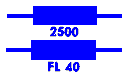
MEA (Minimum Enroute Altitude), shown as altitude or flight level.
Metric MEA converted to feet using standard altimeter setting.
On some chart series, altitudes are provided in both feet and meters. The letter "M" following an altitude in italic type is the metric altitude.
MEA is established with a gap in nav-signal coverage.
Directional MEAs as indicated.
MOCA (Minimum Obstruction Clearance Altitude).
Route MORA (Route Minimum Off-Route Altitude). See glossary.
MAA (Maximum Authorized Altitude), shown as altitude or flight level.
MEA change, limit of MAA applicability or MAA change. Also MOCA or MORA change when MOCA or MORA is charted with no MEA. Symbol is omitted at navaid.
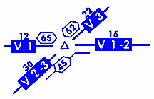
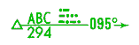
Mileages. Total mileage between navaids
VOR radial & route bearings (magnetic)
VOR Radial and route bearings (True in the Northern Domestic Airspace of Canada).
ADF Bearings (inbound or outbound) Bearings are magnetic unless followed by a "T" indicating True.
ADF Bearings include an arrow to indicate the direction of flight or, when used to designate Fixes, direction to the station. In remote or oceanic areas where ground based navigation aids are not available, the arrow indicates the direction of flight.
ADF bearings (True at track midpoint in the Northern Domestic Airspace of Canada).

The navigation frequency COP (changeover point) between two stations is indicated by mileages from the station to the point of change. Omitted when at midpoint or turning point
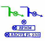
Means even thousands altitudes/flight levels are used in the direction of the arrow and odd thousands in the opposite direction. For application of this symbol above FL 290, the flight levels 310, 350, 390, etc. (left half of the cruising level rose) are considered even. The symbol is shown where altitude/flight level assignment is opposite that shown in the standard cruising altitude/flight level rose.
Means all altitudes, even and odd, are available in the direction indicated.
Means odd thousands altitude/flight level per the above definition. "O" is used only on one way airways to show that odd altitude/flight level assignments apply.
Prior Permission Required from ATC for flight in the direction of the arrow.
Enroute chart excerpt:
AIRWAY NAVAID/REPORTING POINT BY-PASS
When an airway passes over or turns at a navaid or reporting point, but the navaid is not to be utilized for course guidance and/or no report is required, the airway centerline passes around the symbol. In cases where a by-pass symbol cannot be used, an explanatory note is included.
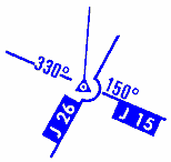
Airway J-26 does not utilize the navaid or reporting point.
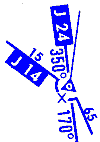
Airway J-14 turns at the navaid or reporting point but does not utilize them. A mileage break "X" is included to further indicate a turn point.
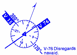
Airway V-76 does not utilize the navaid. A note indicating the proper use of the navaid is included.
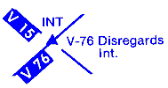
Airway V-76 does not utiIize the Int. A note indicating the proper use of the lnt is included.