Enroute - High Altitude Charts
The following legend, applicable to High Altitude Charts only, is in addition to the other parts of the Enroute chart legend. Many items in the other parts of the legend are also applicable to the High Altitude Charts.
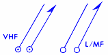
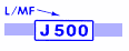
VHF, L/MF Navigational Facilities.
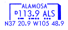
Geographical coordinates (latitude and longitude) of each facility are shown across the bottom of the facility box.
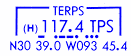
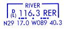
The letter (H) indicates an H-class facility. The letter (L) indicates an L-class facility. The letter (T) indicates a T-Class facility. "D" indicates the availability of DME. In areas of congestion, off-route facility geographical coordinates are shown in an alphabetical listing elsewhere on the chart.

US High Altitude "Enroute Flight Advisory Service". Name of Air Route Traffic Control Center to call, followed by "FLIGHT WATCH". Remote outlet name is included within parentheses. Service is provided between 0600 and 2200 daily.
Jet routes. The thin route centerline is used on United States and Canada-Alaska chart series in areas of congestion.
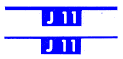
Canada LF/MF High Level airways.

Europe high level airway/route.

South America high level airway/route.

Pacific high level airway/route.

Japan Jet routes at and above FL 240.
One-way airway/route.

One-way preferred route 24 hours unless hours are indicated. Two-way during other hours.

MEA (Minimum enroute altitude)-shown only when higher than floor of the high altitude structure.