Boundaries
BOUNDARIES

ADIZ, DEWIZ and CADIZ

FIR, UIR, ARTCC or OCA boundary.

International boundary

Time zone boundary.

QNH/QNE-boundaries
ALTITUDE LIMITS AND TYPES OF CONTROL

CTR-Control Zone
ATZ-Aerodrome Traffic Zone
TIZ-Traffic Information Zone

UTA-Upper Control Area

TMA-Terminal Control Area
OCTA-Oceanic Control Area
CONTROLLED AIRSPACE

Controlled airspace shown in white.
Uncontrolled airspace shown as a tint.

Controlled airway/route.

Uncontrolled airway or advisory route.

Control Area boundary within controlled airspace (CTA, TMA).

U.S. Class B airspace. Waffle screen shows lateral limits.

Radio Frequency Sector Boundary.

Radio boundaries of control or service unit.

Boundaries within TMAs or CTAs defining different altitude limits and/or sectorizations.

U.S. special VFR weather minimums for fixed wing aircraft are not authorized within the lateral boundaries of the surface areas of Class B, Class C, Class D, or Class E airspace designated for an airport.
Australia Mandatory Traffic Area. Traffic information is exchanged while operating to or from an airport without an operating control tower within the area.

Control Zone or Aerodrome Traffic Zone (controlled).

Aerodrome Traffic Zone (no control). Aircraft broadcast intentions on standard enroute frequency, and listen on same when within such zones.
Japan Information Zone (no control) within which special VFR may be cleared by an air-ground station.

U.S. Class C airspace.

Canada Class C airspace.
ICAO AIRSPACE CLASSIFICATIONS
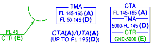
Airspace classification is designated by the letters (A) thru (G). Classification (A) represents the highest level of control and (G) represents uncontrolled airspace. The definitions of each classification are found in the Glossary and the Enroute sections and Air Traffic Control section of the airway manual. The airspace classification letter is displayed in association with the airspace type and vertical limits.